$17,985.00
21.58 acres | Forest / Conservation Zoning
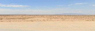
Take a look at this large 21.58 acre property positioned only about 12 miles Northeast of Calipatria and less than 200 miles from Los Angeles. This property is flat with dirt road access. Investigate and learn for yourself what an interesting and vital area this can be.
Land Specifics Foreclosed
| Property Number | 4010 |
|---|---|
| Size | 21.58 acres |
| Dimensions | 1505' x 330' x 1320' x 1050' |
| Road Access | Dirt Road |
| Slope Description | Mostly Flat |
| Zoning | Forest / Conservation |
| Zoning Code | S-2 (Open Space Preservation) |
| Zoning Definition |
S-2 (Open Space Preservation): Family dwellings allowed, one per legal parcel. Accessory agricultural buildings, structures and uses including farm buildings, housing of agricultural product, garages and implementation shelters, provided no livestock or any building or enclosure used in connection with livestock shall be closer than 100 feet to the property lines. Maximum height limit in the S-2 zone shall be 40 feetYards and setbacks in the S-2 zone are as follows: A. FRONT YARD. The front yard minimum setback for all buildings shall be as follows: 30 feet minimum from property line or 80 feet from center line of adjacent road. B. SIDE YARD 20 Feet minimum. REAR YARD 20 feet minimum |
| On Property Usage/Potential |
|
| Nearby Usage |
|
Location
| County | Imperial |
|---|---|
| State | California |
| Other Maps |
|---|
Additional Information
| Assessor Parcel Number (APN) | 025 290 071 |
|---|---|
| Estimated Annual Taxes | $563.30 |
| Legal Description |
That Portion of the Northeast Quarter of the Northeast Quarter of Section 36, Township 11 South, Range 15 East, S.B.M., in the County of Imperial, State of California, according to the official plat of said land approved by the Surveyor General August 21, 1956. Lying Northerly of the Southern of the Southern Pacific Railroad right of way, as located January 6, 1965. Grant Deed dated on January 8, 1965, recorded March 2, 1965, Book 1202, Page 281. Full Reconveyance recorded April 17, 1972, Book 1305, Page 233. LESS, Beginning a strip of land 50.00' wide lying on the Northeasterly side of the Southern Pacific Rail Road right of way and measured at right angles from the Northeasterly right of way line of the Southern Pacific Railroad, wtih side lines of said 50.00 feet wide strip of land terminating on the west at the westerly line of the northeast quarter, of the northeast quarter of section 36, T. 11 S, R 15 E, and terminating on the east at the easterly line of the northeast quarter, of the northeast quarter of said section 36. |
| Monthly HOA Dues | $0 |
| HOA | |
| HOA Dues | $0 |
| HOA Info |
This property has been sold.
This property is no longer available.
Use My LandCentral to be notified when a similar property is available in the future.
Or search available properties now:
Search Properties